Just looking at http://www.nbnco.com.au/industry/service-providers/network-rollout/boundaries.html
And they offer some zip files which contain MID and MIF extensioned files. Which are MapInFo vector overlays to show where they are putting fibre in. I didn't really know what to do with them when I first downloaded them.
However I found a program named QGIS (yum install qgis) which has the ability to load them as a layer... wasn't much use until I installed qgis-python, restarted QGIS and then used the Plugins -> Fetch Python Plugins to install the OpenLayers Plugin which loads Google or Open Street Map layers to allow the MIF / MID File overlays to make sense.
Example MIF contents:
Version   600
Charset "WindowsLatin1"
Delimiter ","
Index 1
CoordSys Earth Projection 1, 116
Columns 1
  id Char(30)
Data

Region  1
  60
153.023899 -27.3742
153.024999 -27.373332
153.028688 -27.373908
153.028826 -27.373157
153.028872 -27.372899
153.028948 -27.37291
153.029396 -27.370552
153.029381 -27.370477
153.029399 -27.370407
153.02957 -27.370044
153.029674 -27.369587
Example MID Contents:
"4APL-01"
"5SFD-01"
"4NDG-03"
"4TOB-04"
"6MSP-03"
"3SMR-01"
"2RCH-01"
"7LAU-02"
"5PTA-01"
"7HOB-03"
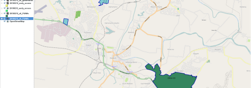
And here it is with the MIFs and MIDs loaded.
And disappointingly non of the areas outlined contain my house. The nbn.com.au website says construction will start sometime before 2014...
I would love fibre to the home and to my work I could move from an onsite everything shop to co-locating with a cloud provider and get dressed in my jammies to go to work.
So this is my answer to my Google Search "How do I open MIF files on Linux"


0 Comments